Part 4: Appalachian Trail & Mountains to Sea trail. Winding Stair Gap to Oconaluftee visitor center GSMNP 120 miles
Notes:
- This section occurred from May 23-30
- Water sources: No issues
- Permit: Yes - GSMNP
- Camping restrictions: Required to sleep in shelters in GSMNP (with few exceptions)
Day 11 Winding Stair Gap to .1 mile past Cold Spring Gap Shelter 15.8 miles
Bobby the Greek shuttled me from Oconaluftee Visitor Center (GSMNP) near Cherokee, NC to Winding Stair Gap ($60) for this 120 mile section.
I have had this section of the AT on my list for some time - it passes Wayah Bald & Wesser Bald, then continues on to the NOC. It was exciting to finall see it. After getting dropped off, I hit the trail. I felt rested and the mileage came easy. Maybe I was getting some trail legs?
It didnt seem long and I was at Wayah Bald. I didnt know it was a place you could drive up to. You can see burned trees nearby from a fire in 2016 that also damaged the tower, which has since been repaired. The views were great and I could see Rabun Bald where I had been previously.
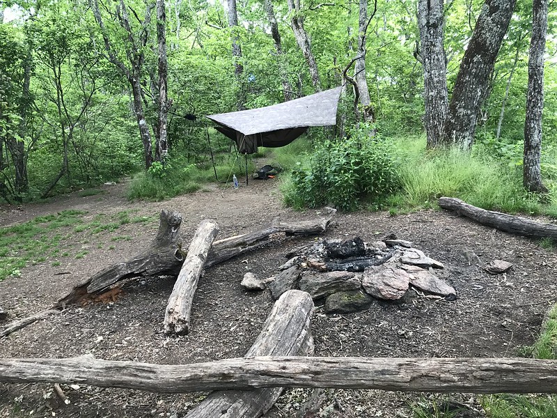
I continued on and camped .1 mile past Cold Spring Gap Shelter, at a place on the ridge with views down the valley. I could hear some folks at the shelter but didnt meet them until later (3 girls thru hiking).
Day 12 Cold Spring Gap shelter to random camp north of NOC 14.2 miles
Up at 7am. Maybe Ill turn into a morning person yet. Haha JK.
I got to the Wesser Bald lookout tower. Its different than a lot of other towers in that its like a 20x20 platform on top. Great 360 degree views. I laid on my back and watched the clouds float by as the sweat dried from my shirt as it hung on the railing.
Then it was a loooong downhill to the Natahala Outdoor Center (NOC), where I stopped for a burger, fries, Coke and later beer by the river. I found the coveted seat next to the electric outlet. Fun watching the kayaks and recalling our time in duckies on the river. Put my legs in the water and it was as cold as I remembered.
Chafing sucks. I realized at the NOC I had gone from from 0/10 to 9/10 chafing problems. Applied some body glide but it was too late so I cowboy walked up the trail until I hit the first camp with water a few miles after the railroad tracks. The fun part was 5 other thru hikers joined (the camp, not the cowboy walk) so I got to enjoy the trail conversation. Oh and one hiker shared a beer. Score.
Day 13 Just past NOC to Cable Gap Shelter 19.8 miles
I planned a long day to setup a short hike into Fontana Village the next day, so I got around and left before the others. One aspect I look for in my gear is simplicity so I can setup and take down when needed. That helps offset me sleeping in

The climb up Cheoah Bald was a long consistent uphill, so I was happy when I reached the top. More views and another sunny day.
Water strategy became important. There wasnt a lack of water but some water sources werent real close to the trail. Who wants to walk an extra mile when you dont have to.
I took a break at Stecoah Gap then found myself climbing and climbing. About midway up I recalled Jacobs Ladder is in the area and sure enough I had found it. Thankfully it wasnt too long but I was glad to be done with it.
Finally, I thought I was getting close to Cable Gap shelter but realized I had read the mileage for Cody Gap on a sign. Ugh. I made it eventually. Nice spot to hammock with a creek nearby. Just under 20 miles on the day and 50 the last three days. Doing better than I expected.
Day 14 Cable Gap Shelter to Fontana Dam / Village 6.5 miles
Enjoyed talking to two SOBOs last night at the shelter - Treeman and Bobsled. Maybe its best not to talk to thru hikers to avoid the FOMO?
I saw 3 headlamps on trail around 5:30 am and found out they belonged to the thru hikers I stayed with the day before. They had gotten an early 4 am start to get to Fontana Village. The promise of a breakfast buffet will do that to you. Heck even I was on trail at 6. Thats am not pm.
Since Im on a route and not adhering to a certain trail, I decided to take an alternate trail to Fontana Village that the SOBOs saw the day before. At Walker Gap, a Yellow Creek Mountain trail stays along the ridgeline and connects to the Bartram trail, which drops right into Fontana Village, saving me from shuttling to the lodge. The downside was the connector trail was overgrown and steep downhill. I eventually made it and enjoyed the buffet. Then 3 hours later lunch
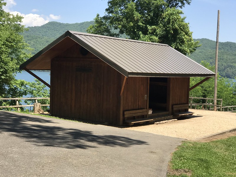
. I picked up a resupply box at the lodge and then spent the night at the Fontana Hilton, which is just a fancy shelter. I found a couple trees up from the shelter.
I did some laundry using water from the water pump, a trash compactor bag and soap. Eventually others came to the shelter but I was so tired I stayed in the hammock and went to bed early. Nice rest day with only 6.5 miles done.
Day 15 Fontana Hilton to Mollies Ridge shelter 12 miles
I crossed Fontana Dam in the morning, as the trail goes right over the dam. I stopped in the visitor center bathrooms to refill my water bottles. Surprisingly nice showers but I decided to embrace the stink.
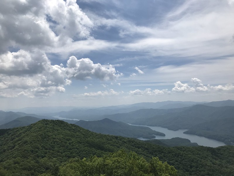
My knee hurt a bit from the steep downhill the day before so I took it easy. Well as easy as you can take it when climbing 4,000 in the Smokies. Eventually took the side trail to Shuckstack lookout tower - good choice. Bit sketchy going up the tower but the views - wow. Worth it. One of my favs.
Lucked out with an overcast day and some wind to keep me cool during the climb. Made it to Mollies Ridge and called it a day. One thru hiker at the shelter I called Shackleton told me how he started the trail carrying 30 days of food.
Another thru hiker came running.. err sprinting back up the side trail from the water source having seen a BEAR, with it even standing up to look at her. Im not sure running was the smartest thing but she did look faster than me so maybe that was her plan. Fittingly her trail name was hare. #SouthernAppalachian500
Day 16 Mollies Ridge shelter to Double Springs Gap shelter 19.5 miles
Climbing from Fontana Dam 1,600 to Clingmans Dome 6,600 is tough. But consider the total ascent is closer to 10,000 and you really respect this stretch of trail.
The AT in the Smokies requires you to sleep in the shelters with a few exceptions. I used a brand new inflatable REI sleeping pad the night before and it leaked air. I had to blow it up again in the middle of the night. Ugh. And it needed blown up again in the early morning but I was too lazy to do it so I suffered.
I sauntered along the trail, my knee feeling much better. Went by Spence Ridge; Rocky Top TN (everybody sing the song now); and Silers Bald. Eventually made it to Double Spring Gap shelter, where I slept that night. The shelter was full so I hung in my hammock on some trees. It was a big day - just under 20 miles. That set me up to get back to my car with 2 more days hiking.
I had been crossing paths with three thru hikers I met outside the NOC - Irene, Summer and Alana... otherwise known as Teeter, Pots and Pans, and Chickadee. Gotta admit I had a bad case of FOMO that they were going to Katahdin and I was not. Maybe some year.
Day 17 Double Springs Gap shelter to Bryson Place campsite 57 16.2 miles
The shelter filled up last night so I got to sleep in the hammock - a welcome change from the leaking air mattress. One guy slept on the bench all night - how he didnt fall off I have no idea.
I set out with the 3 thru hikers towards Clingmans Dome. It was only ~3 miles so we were there in no time. The observation deck was fogged in but it was still special to have accomplished all that elevation gain from Fontana Dam. And it felt good to add the highest point in TN to my growing list on this route - the highest in SC (Sassafras) and 2nd highest in GA (Rabun Bald). This also is the first of many 6,000 mountains on the route. .
The Mountains-To-Sea trail (MST) starts here and parallels the AT for 3 miles before turning off onto the Fork Ridge trail. I said goodbye to my thru hiker mates and wished them well. Kinda fun to start the 4th major trail of this route - Foothills->Bartram->AT->MST.
I hiked downhill on the MST for what seemed like forever until I got to Deep Creek. The trail here was more overgrown and the no-see-ums were crazy - flying in my eyes, ears and nose even with deet on. I quickened my pace and wore headphones until finally arriving at the Bryson Place campsite. I think this is the best campsite along this stretch if you can make it. I ate my mashed potatoes for dinner and setup the hammock. I was back to having the whole campsite to myself.
Day 18 Bryson Place campsite 57 to Oconaluftee Visitor Center 13.9 miles
I woke up, enjoyed my last coffee on the trail, and headed up the climb to Newton Bald, carrying a couple liters of water as its a dry ridgeline hike.
I've been to Newton Bald before on an hike the prior fall on the MST. At that time the MST continued on to SmokeMount campground & the route was known as "1A". Today I followed the new official route down the Mingus Creek trail. I eventually popped out near Oconaluftee visitor center & my truck.
Overall this section was 120 miles and fantastic. It was mostly on the AT, with the last 20+ miles on the MST. I'd recommend this one if you are looking for something to do.


Originally Posted by infrastellar


 Reply With Quote


Bookmarks